-
Google Earth A Revolutionary Tool – The Photos That Sparked Protests in Bahrain
03 Mar 2011 by Jasmine Stone in Gadgets, Media, Tech/Sci, World

In the age of information, nothing can be kept in the dark anymore. These are the so called controversial Google Earth photos that initially set off Bahraini protests of inequality back in 2006. And when you see them, you’ll know why.
According to the Business Insider:
A few years ago, Bahrain’s oppressed and overcrowded Shiite majority began using Google Earth to view palaces and other estates that make up 95% of the country. As these images churned up discontent, the government blocked Google Earth. However, an anonymous PDF guide was distributed by email. The NYT’s Tom Friedman also names these images in a list of “not-so-obvious forces” that fed the mass revolt.
The core of the PDF argument is that the royal family and private landowners are hogging the coastline (some say 90% of the coastline is private and permits no public access) and living in flipping mansion and palaces while the rest of Bahrain have to make do living in crappy-ass shacks. Just another reminder of what goes on when the government thinks we aren’t looking. Greed and selfishness like this makes me ashamed to part of the human species. But then again, I’ve always secretly wanted to be a manatee…
The royal family’s spending is protected by law from public scrutiny, making Google Earth one of the only ways that citizens can keep tabs on their royals.
Follow the link below for more images.
[Source: Theblaze]
Latest News
-
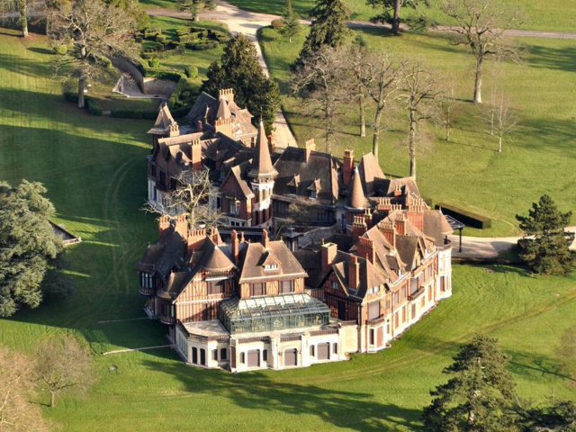
Mystery Middle Eastern Billionaire Is Selling The World’s Most Expensive Home For R8,7 Billion
[imagesource:x/@LeDesk_ma] A castle outside Paris once owned by a member of the Rothsch...
-

Now For The Dark Comedy TV Series That Scored 100% On Rotten Tomatoes [Trailer]
[imagesource:netflix] If you’re looking for something to watch on Netflix, then defin...
-

The New AI Paintball-Blasting Home Security Camera Is Quite Happy To Choose Violence [Video]
[imagesource:paintcam/facebook] Taking 'enter at your own risk' to a whole new level, a...
-

Why SA’s Middle Class Is Losing Their Wealth
[imagesource:insauga] If you consider yourself a middle-class South African, then you p...
-
Banker Drowns In ‘Baptism-Style Exorcism’ To Rid Him Of Demon Called ‘Dirty Dan’
[imagesource:flickr] A successful US banker was drowned in a pond during an alledged �...
-
-
-
2oceansvibe Partners
-


-